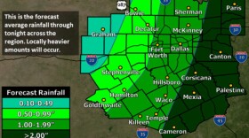
National Weather Service meteorologist Lamont Bain says the tornado that hit on Thursday afternoon was an EF0 — it had winds up to 85 miles per hour, according to The Associated Press.
Update 5:52 p.m.: The tornado watch for North Central Texas is still in effect until 8 p.m.
The tornado threat for Tarrant County ended shortly before 5 p.m. Tornado warnings were in effect for Denton, Cooke and Grayson counties through 5:45 p.m.
Tornado Warning including Denton TX, Corinth TX, Pilot Point TX until 5:45 PM CST pic.twitter.com/ZI03JX8bvl
— NWS Fort Worth (@NWSFortWorth) November 5, 2015
Although it was over in minutes, the tornado that went through Tarrant County around 4:30 p.m took the part of roof off a Compass Bank building near Meacham Boulevard and I-35.
Watch video of the storm:
Here's what The Morning News is reporting:
"It’s also worth noting that the main line of storms remains to the west of Dallas-Fort Worth. And the sun is out in downtown Dallas, which forecasters warn could destabilize the atmosphere in advance of the storms’ slow approach. Dallas remains under the gun between now and 9 p.m."
Here's the image captured of the building after the storm.
Tornado touched down in north-east fort worth. @ericbrown87 grabbed this of opposite building. Did some damage. pic.twitter.com/Y6hwhEqOxB
— Vinod Srinivasan (@VinVasan) November 5, 2015
Update, 4:28 p.m.: The National Weather Service has confirmed a tornado warning in Northeast Tarrant County.
Tornado Warning including North Richland Hil TX, Bedford TX, Grapevine TX until 4:45 PM CST pic.twitter.com/inSzmbbnuN
— NWS Fort Worth (@NWSFortWorth) November 5, 2015
Original post: It was a quiet morning, but the potential for severe weather is growing this afternoon. The National Weather Service has issued a tornado watch until 8 p.m. for Dallas and surrounding counties.
Although the first round of storms in the forecast didn't do much this morning, anticipate the second round this afternoon, the weather service says.
Here is a look at the short term threat assessment through 5 pm. #txwx #dfwwx #texomawx pic.twitter.com/PLZuMgVmxG
— NWS Fort Worth (@NWSFortWorth) November 5, 2015
1115AM: Severe weather chances are increasing across #dfwwx & #texomawx Severe storms may develop after noon pic.twitter.com/c27VLC9aRo
— NWS Fort Worth (@NWSFortWorth) November 5, 2015
Surprised by a tornado watch in November? Not as common as April or May, but this is a secondary peak. #dfwwx #txwx pic.twitter.com/hXhoU1Ff1Q
— NWS Fort Worth (@NWSFortWorth) November 5, 2015
Here's what The Dallas Morning News is reporting:
At this very moment, a line of storms is forming to the west of Dallas-Fort Worth, stretching from Wichita Falls to the southwest. The individual storms associated with that dry line are moving to the northeast at 45 mph, says Dennis Cain in the National Weather Service’s Fort Worth office. But the line itself is crawling at 10 mph. Cain says that given its current pace, the storms could impact Dallas around 6-9 p.m.
The Fort Worth Star-Telegram is reporting:
A line of thunderstorms is firing up Thursday west of Fort Worth that should rumble into the Dallas-Fort Worth area late this afternoon or this evening. “They’re already starting to go way off to the west,” said National Weather Service meteorologist Mark Fox. “They’ll be slowly moving this way this afternoon. We expect to see a line of thunderstorms a little bit later.”
The Weather Service also has a flood warning in effect for the Trinity River from late tonight until Saturday morning, unless the warning is canceled earlier.
Check back for updates throughout the day.


